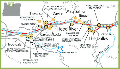
Rock Fort Campsite
 �
Corps Historic Site �
Corps Historic Site
�
Corps Campsite
A riverfront trail will lead visitors to Rock Fort where
interpretive signage marks the Corps� October 25-28, 1805 and
April 15-17, 1806 campsites. Interstate 84, The Dalles, Oregon

Columbia Gorge Discovery Center and
Wasco County Historical Museum
�
Corps Historic Site
�
Corps Campsite
�
Historic Tribal Site
Lewis and Clark camped at
this site
October 28, 1805. View photographs and a film of Celilo Falls
fishery, and displays on the Lewis and Clark Expedition.
Interstate 84, The Dalles, Oregon.
Memaloose State Park
�
Corps Historic Site
�
Historic Tribal Site
Lewis and
Clark called
this offshore island �Sepulchar Island,� also known as
Sepulchar Rock. Historically, this island was used by tribal
nations as a burial ground. Interstate 84, Mosier, Oregon.
Hood River County Historical Museum
�
Museum / Interpretive Center
See tribal artifacts, including Klickitat baskets, at
this museum
in historic Hood River. Interstate 84, Oregon.
Columbia Gorge Interpretive Center
�
Corps Historic Site
�
Museum / Interpretive Center
View Lewis and Clark-related exhibits and a multi-media presentation
on the history of the Columbia Gorge. See the site where Lewis and
Clark had to find a way around the rugged Cascade Rapids. These were
the last rapids the Corps experienced before reaching the calmer tidal
waters of the lower Columbia River. Highway 14, Stevenson,
Washington.
Cascade Locks Marine Park
�
Historic Tribal Site
�
Museum / Interpretive Center
Cascade Locks is
rich with Native American history and culture, including the legend of
the �Bridge of the Gods.� Access hiking (the Pacific Crest Trail
passes through here), waterfalls and scenic vistas. Visit the Cascade
Locks Historical Museum for an intriguing look at the past. Cascade
Locks, Oregon.
Bonneville Dam/Hamilton Island
�
Corps Historic Site
�
Corps Campsite
Hamilton
Island, referred to as Strawberry Island in Lewis and Clark�s
journals, was the Corps� campsite, April 10-11, 1806. At
Bonneville Dam, watch salmon move up the fish ladder from
outside and from inside viewing windows. The visitor center
includes a �Lewis and Clark on the River� exhibit. off Interstate
84 in Oregon, SR 14 in Washington.
Beacon Rock and Beacon Rock State Park
�
Corps Historic Site
Here the
Corps first detected the tidal influences of the Pacific Ocean,
and Clark referenced �Beaten� rock in his journal. Follow the
trail to the summit of
Beacon Rock - believed to be the core of an extinct volcano -
for a panoramic view of the Columbia River Gorge. Highway 14, 35
miles east of Vancouver, Washington.
Rooster Rock State Park
�
Corps Historic Site
�
Corps Campsite
Interpretive signage marks where the Corps camped November 2, 1805
and April 7-8, 1806. Enjoy three miles of sandy beaches and a swimming
area. Boat launch. Interstate 84, east of Portland, Oregon.
Lewis and Clark State Recreation Site
�
Corps Historic Site
This area, along the Sandy River, was explored by the Corps�
hunters, who called it �Quicksand River.� Enjoy fishing, swimming
and hiking. Interpretive signage and boat launch. Off Interstate
84, 16 miles east of Portland, Oregon.
 |